Showing 4439 items matching residential development
-
 Greensborough Historical Society
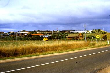
Slide - Photograph, John Ramsdale, Residential development, Whittlesea: Slide 68, 1990s
... Residential development, Whittlesea: Slide 68...residential development...Photograph shows a residential development in Whittlesea....Photograph Slide Residential development, Whittlesea: Slide ...Photograph shows a residential development in Whittlesea.Part of the John Ramsdale collection of slides and audio visual material.Colour photograph scanned from slide.No maker's marks. No caption on slide.residential development, whittlesea -
 Greensborough Historical Society
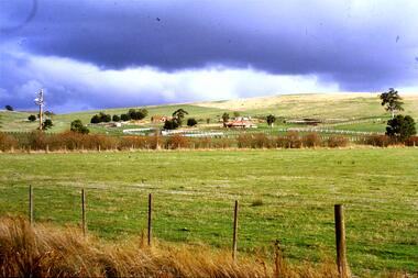
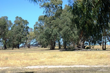
Slide - Photograph, John Ramsdale, Residential development south of Whittlesea: Slide 92, 1990s
... Residential development south of Whittlesea: Slide 92...residential development...Photograph shows residential development south...Photograph Slide Residential development south ...Photograph shows residential development south of Whittlesea encroaching on farmland.Part of the John Ramsdale collection of slides and audio visual material.Colour photograph scanned from slide.No maker's marks. No caption on slide.whittlesea, residential development -
 Eltham District Historical Society Inc
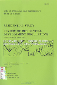
Document - Book, Econsult Planning and Development Pty Ltd, Residential Study: Review of Residential Development Regulations; Final Report; Volumes 1 and 2, October 1991
... Residential Study: Review of Residential Development...residential development... residential development Housing Econsult Planning and Development Pty ...Report by Consultants Econsult Planning & Development produced under the Steering Committee guidance of the City of Doncaster and Templestowe and the Shire of Eltham recognising a lack of diversity in housing stock to meet changing housing needs. The Study objectives are: *To provide for a wide variety of housing choices and lot sizes *To make housing more accessible taking into account the Australian Model Code *To maintain residnetial amenity by taking into account significant local features *To prepare guidelines and policities which consider slope, lot, size, location, availability of services and significant vegeation. *To determine the housing types and lot sizes, required by new residents in different locationsresidential development, housing -
 Whitehorse Historical Society Inc.
Pamphlet, Multi Unit Residential Development Controls, 1/03/1986
... Multi Unit Residential Development Controls...Review of Multi Unit Residential Development controls: your... Development Controls Review of Multi Unit Residential Development ...Review of Multi Unit Residential Development controls: your chance to comment including present and proposed density zone maps.land use, city of nunawading -
 Greensborough Historical Society
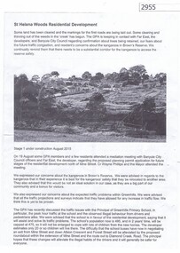
Article, Greenhills Progress Association, St Helena Woods Residential Development, 19/08/2015
... St Helena Woods Residential Development... and residents about the St Helena Woods residential development by Far... residential development by Far East. st helena woods greenhills ...Concerns by the Greenhills Progress Association and residents about the St Helena Woods residential development by Far East.One page, text and photograph st helena woods, greenhills progress associatiion -
 Greensborough Historical Society
Photograph - Digital image, Marilyn Smith et al, Janefield Precinct: Looking towards the future - new residential development, 27/11/2014
... residential development.... residential development. The remains of this site are between... towards the future - new residential development. The remains ...Janefield Precinct: Looking towards the future - new residential development. The remains of this site are between Greensborough and Janefield. A RAAF Hygiene Training Camp was located on the Plenty River, just south of the Janefield community. It was in use from 1944 to 1946. The Camp was constructed from salvaged materials. Instruction included building and maintenance of grease traps, latrines, elementary plumbing and carpentry.Early remains of a WW2 training camp Digital colour photograph.janefield -
Whitehorse Historical Society Inc.
Document, Winlaton, 1/11/2008 12:00:00 AM
... Residential development... was demolished in the early 1990s for residential development....'. The Building was demolished in the early 1990s for residential... in the early 1990s for residential development. The property was later ...Short history of 'Winlaton', a grand home built by J. T. Tweddle in 1909.Short history of 'Winlaton', a grand home built by J. T. Tweddle in 1909. The property was later converted to an institution for girls named 'Winlation Youth Training Centre'. The Building was demolished in the early 1990s for residential development.Short history of 'Winlaton', a grand home built by J. T. Tweddle in 1909. winlaton youth training centre, residential development -
Port Melbourne Historical & Preservation Society
Photograph - Port Melbourne residential development 1996, Ron Laing, 1988 - 1999
... Port Melbourne residential development 1996... Street) Port Melbourne melbourne Port Melbourne residential ...Part of Ron Laing's collection of photographs recording Port Melbourne over a thirteen year period. Donated to the PMH&PS by the photographer.One of a set of 20 colour photographs 1980s-90s, of various events and subjects. View looking East from Princes Pier in June 1996 showing Port Melbourne residential redevelopment underwayron laing -
Glen Eira Historical Society
Document - RESIDENTIAL DEVELOPMENT POST AUGUST 2013 IN GLEN EIRA
... RESIDENTIAL DEVELOPMENT POST AUGUST 2013 IN GLEN EIRA... VIC 3162 melbourne RESIDENTIAL DEVELOPMENT POST AUGUST 2013 ...This file has folder A only awaiting checking -
Whitehorse Historical Society Inc.
Document, Whitehorse, 1/04/1998 12:00:00 AM
... Residential Development...- residential development.... facts. Municipal fact sheet series- residential development ...Whitehorse key facts. Municipal fact sheet series- residential development.Whitehorse key facts. Municipal fact sheet series- residential development.Whitehorse key facts. Municipal fact sheet series- residential development.city of whitehorse, residential development -
Whitehorse Historical Society Inc.
Article, Whitehorse vision for Healesville, 2014
... and some residential development covering 19% of the land.... and some residential development covering 19% of the land.... and some residential development covering 19% of the land ...City of Whitehorse Vision for Healesville Freeway Reservation.City of Whitehorse Vision for Healesville Freeway Reservation to include open space, sustained natural environment and some residential development covering 19% of the land.City of Whitehorse Vision for Healesville Freeway Reservation.healesville freeway reservation, city of whitehorse -
 Greensborough Historical Society
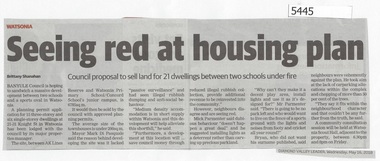
Newspaper Clipping, Diamond Valley Leader, Seeing Red at Housing Plan, 16/05/2018
... residential development... school watsonia primary school residential development banyule ...Banyule Council is hoping to sandwich a massive development between two schools and a sports oval in Watsonia.News article 1 page, black text.watsonia, knight street watsonia, concord school, watsonia primary school, residential development, banyule city council -
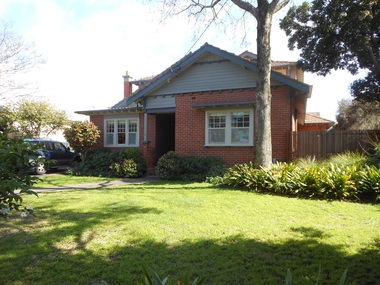
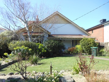
 Surrey Hills Historical Society Collection
Photograph - 1 Barloa Road, Surrey Hills, The Street Where You Live Project
... higher density residential development or renewal of single... residential development or renewal of single dwellings. At particular ...Photos documenting this address as part of a photographic series undertaken by volunteer photographers during 2013 and 2014 for The Street Where You Live Project. This was organised through the Surrey Hills Neighbourhood Centre and covered the postcode 3127 in the cities of Boroondara and Whitehorse.these photos provide a snapshot of real estate in the suburbs of mont albert and surrey hills during a period of rapid change with many properties on large blocks demolished to create higher density residential development or renewal of single dwellings. at particular risk were properties not covered by heritage overlays, especially interwar housing and post 1950's housing. -
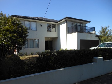
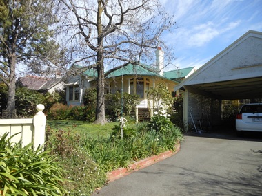
 Surrey Hills Historical Society Collection
Photograph - 2 Barloa Road, Surrey Hills, The Street Where You Live Project
... higher density residential development or renewal of single... residential development or renewal of single dwellings. At particular ...Photos documenting this address as part of a photographic series undertaken by volunteer photographers during 2013 and 2014 for The Street Where You Live Project. This was organised through the Surrey Hills Neighbourhood Centre and covered the postcode 3127 in the cities of Boroondara and Whitehorse.these photos provide a snapshot of real estate in the suburbs of mont albert and surrey hills during a period of rapid change with many properties on large blocks demolished to create higher density residential development or renewal of single dwellings. at particular risk were properties not covered by heritage overlays, especially interwar housing and post 1950's housing. -
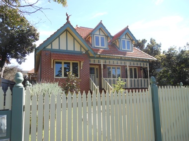
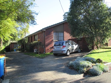
 Surrey Hills Historical Society Collection
Photograph - 3 Barloa Road, Surrey Hills, The Street Where You Live Project
... higher density residential development or renewal of single... residential development or renewal of single dwellings. At particular ...Photos documenting this address as part of a photographic series undertaken by volunteer photographers during 2013 and 2014 for The Street Where You Live Project. This was organised through the Surrey Hills Neighbourhood Centre and covered the postcode 3127 in the cities of Boroondara and Whitehorse.these photos provide a snapshot of real estate in the suburbs of mont albert and surrey hills during a period of rapid change with many properties on large blocks demolished to create higher density residential development or renewal of single dwellings. at particular risk were properties not covered by heritage overlays, especially interwar housing and post 1950's housing. -
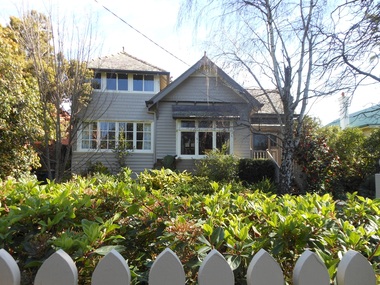
 Surrey Hills Historical Society Collection
Photograph - 4 Barloa Road, Surrey Hills, The Street Where You Live Project
... higher density residential development or renewal of single... residential development or renewal of single dwellings. At particular ...Photos documenting this address as part of a photographic series undertaken by volunteer photographers during 2013 and 2014 for The Street Where You Live Project. This was organised through the Surrey Hills Neighbourhood Centre and covered the postcode 3127 in the cities of Boroondara and Whitehorse.these photos provide a snapshot of real estate in the suburbs of mont albert and surrey hills during a period of rapid change with many properties on large blocks demolished to create higher density residential development or renewal of single dwellings. at particular risk were properties not covered by heritage overlays, especially interwar housing and post 1950's housing. -
 Surrey Hills Historical Society Collection
Photograph - 5 Barloa Road, Surrey Hills, The Street Where You Live Project
... higher density residential development or renewal of single... residential development or renewal of single dwellings. At particular ...Photos documenting this address as part of a photographic series undertaken by volunteer photographers during 2013 and 2014 for The Street Where You Live Project. This was organised through the Surrey Hills Neighbourhood Centre and covered the postcode 3127 in the cities of Boroondara and Whitehorse.these photos provide a snapshot of real estate in the suburbs of mont albert and surrey hills during a period of rapid change with many properties on large blocks demolished to create higher density residential development or renewal of single dwellings. at particular risk were properties not covered by heritage overlays, especially interwar housing and post 1950's housing. -
 Surrey Hills Historical Society Collection
Photograph - 5A Barloa Road, Surrey Hills, The Street Where You Live Project
... higher density residential development or renewal of single... residential development or renewal of single dwellings. At particular ...Photos documenting this address as part of a photographic series undertaken by volunteer photographers during 2013 and 2014 for The Street Where You Live Project. This was organised through the Surrey Hills Neighbourhood Centre and covered the postcode 3127 in the cities of Boroondara and Whitehorse.these photos provide a snapshot of real estate in the suburbs of mont albert and surrey hills during a period of rapid change with many properties on large blocks demolished to create higher density residential development or renewal of single dwellings. at particular risk were properties not covered by heritage overlays, especially interwar housing and post 1950's housing. -
 Surrey Hills Historical Society Collection
Photograph - 6 Barloa Road, Surrey Hills, The Street Where You Live Project
... higher density residential development or renewal of single... residential development or renewal of single dwellings. At particular ...Photos documenting this address as part of a photographic series undertaken by volunteer photographers during 2013 and 2014 for The Street Where You Live Project. This was organised through the Surrey Hills Neighbourhood Centre and covered the postcode 3127 in the cities of Boroondara and Whitehorse.these photos provide a snapshot of real estate in the suburbs of mont albert and surrey hills during a period of rapid change with many properties on large blocks demolished to create higher density residential development or renewal of single dwellings. at particular risk were properties not covered by heritage overlays, especially interwar housing and post 1950's housing. -
 Surrey Hills Historical Society Collection
Photograph - 7 Barloa Road, Surrey Hills, The Street Where You Live Project
... higher density residential development or renewal of single... residential development or renewal of single dwellings. At particular ...Photos documenting this address as part of a photographic series undertaken by volunteer photographers during 2013 and 2014 for The Street Where You Live Project. This was organised through the Surrey Hills Neighbourhood Centre and covered the postcode 3127 in the cities of Boroondara and Whitehorse.these photos provide a snapshot of real estate in the suburbs of mont albert and surrey hills during a period of rapid change with many properties on large blocks demolished to create higher density residential development or renewal of single dwellings. at particular risk were properties not covered by heritage overlays, especially interwar housing and post 1950's housing. -
 Surrey Hills Historical Society Collection
Photograph - 1 Neath Street, Surrey Hills, The Street Where You Live Project
... higher density residential development or renewal of single... residential development or renewal of single dwellings. At particular ...Photos documenting this address as part of a photographic series undertaken by volunteer photographers during 2013 and 2014 for The Street Where You Live Project. This was organised through the Surrey Hills Neighbourhood Centre and covered the postcode 3127 in the cities of Boroondara and Whitehorse.these photos provide a snapshot of real estate in the suburbs of mont albert and surrey hills during a period of rapid change with many properties on large blocks demolished to create higher density residential development or renewal of single dwellings. at particular risk were properties not covered by heritage overlays, especially interwar housing and post 1950's housing. -
 Surrey Hills Historical Society Collection
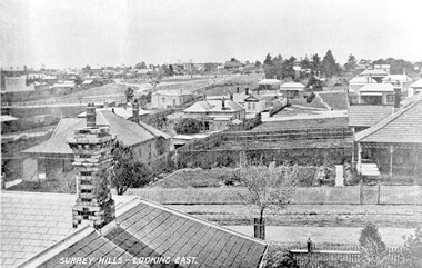
Photograph, Surrey Hills - Looking East from Essex Road, circa 1900, c1900
... residential development... Gardens. edwardian style residential development kirkland essex ...Date is approximate. Two original post cards of this image - "Surrey Hills - looking East" - were donated by Stephen Wyatt on 10 March 2012. One is blank; the other has been sent to Mrs A Wyatt, C/O Mrs E Young, 'Grand View', Warburton from daughter Nellie from 'The Quantocks', Surrey Hills - postmarked 10 Dec 1906. There is also a reproduction of this image in a framed collage of Surrey Hills photos.This is the earliest known image of the Surrey Gardens. The layout was originally designed by William Guilfoyle, who also designed Melbourne’s Royal Botanic Gardens.Black and white photo taken from an early postcard. Taken from the roof of a house in Essex Road, it shows the development of housing between Essex and Union Roads and includes the section of land fenced off for the Surrey Gardens with paths roughly laid out, one existing tree but no tree planting. The houses depicted are largely Edwardian timber buildings with corrugated rooves. There are still some vacant blocks. Kirkland on Union Road can be seen in the distance, as can some of the shops along Canterbury Road.Lower LHS within original image: " Surrey Hills - Looking East"; on the rear "No 17" in black pen in top LH corner.edwardian style, residential development, kirkland, essex road, suffolk road, norfolk road, surrey gardens, post card -
Whitehorse Historical Society Inc.
Article, Zone concern rising, 2013
... Residential development.... Residential development Town planning City of Whitehorse Article ...Article regarding residents concern over development in Whitehorse.Article regarding residents concern over development in Whitehorse.Article regarding residents concern over development in Whitehorse.residential development, town planning, city of whitehorse -
Whitehorse Historical Society Inc.
Article, Resident group calls for open spaces, 2013
... Residential development... and renewed focus on open spaces Residential development Resident ...Whitehorse Residents and ratepayers Association.Whitehorse Residents and ratepayers Association calls for a review of proposed residential hubs and renewed focus on open spacesWhitehorse Residents and ratepayers Association.residential development, resident action, whitehorse residents and ratepayers association -
Whitehorse Historical Society Inc.
Article, Losing the traditional plot, 2008
... Residential development... Vermont Park - an example of cluster living (Photos). Residential ...Vermont Park - an example of cluster living (Photos).Vermont Park - an example of cluster living (Photos). Vermont Park - an example of cluster living (Photos). residential development, vermont park -
Whitehorse Historical Society Inc.
Article, Multi-storey unit project scrapped, 2007
... Residential development... Aubrey Chris Allan Peter Hogg Tony Residential development ...Whitehorse Council has knocked back plans for a 52 unit development at 520 Mitcham Road, Mitcham.Whitehorse Council has knocked back plans for a 52 unit development at 520 Mitcham Road, Mitcham. (Photo of some of the residents opposed to the development)Whitehorse Council has knocked back plans for a 52 unit development at 520 Mitcham Road, Mitcham. mitcham road, mitcham no. 520, aubrey, chris, allan, peter, hogg, tony, residential development -
Whitehorse Historical Society Inc.
Document, Post World War 2 housing in Whitehorse, 2009
... Residential development... by Samantha Westbrooke. Tape at NP3568 Houses Residential development ...Brief history of housing in the eastern section of the City of Whitehorse 1945-20078.Brief history of housing in the eastern section of the City of Whitehorse 1945-20078. Illustrations for a talk given to Whitehorse Historical Society at a General Meeting 18 April 2009 by Samantha Westbrooke. Tape at NP3568Brief history of housing in the eastern section of the City of Whitehorse 1945-20078. houses, residential development, city of whitehorse, city of nunawading, whitehorse historical society inc. -
Whitehorse Historical Society Inc.
Document, Fulton Park Estate, 1970s
... Residential development... South Lana Street Blackburn South Residential development Fulton ...Real estate brochure for the sale of 49 blocks at Fulton Park Estate Blackburn South.Real estate brochure for the sale of 49 blocks at Fulton Park Estate Blackburn South. Agents: E Flintoff & Sons and K F LangReal estate brochure for the sale of 49 blocks at Fulton Park Estate Blackburn South. fulton road, blackburn south, freda court, blackburn south, lucia street, blackburn south, mira street, blackburn south, lana street, blackburn south, residential development, fulton park estate -
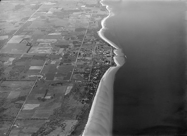 Phillip Island and District Historical Society Inc.
Photograph, Historic aerial photographs of Phillip Island, Cowes, Rhyll, Cape Woolamai and San Remo, 1930s
... residential development... to development and before the bridge was built from the mainland ...Photos taken by an unknown pioneer aviator researched by Kevin O'Reilly who has written a book "Flyers of Time" on pioneer aviation. Photos show the Island and San Remo prior to development and before the bridge was built from the mainland.HistoricalA C D Rom and USB of historic aerial photos about 1930s - 1940s of Phillip Island, Cowes, Rhyll, San Remo and Woolamai. Both formats contain the same 7 photos. Also a letter explaining the history of the photos.photographs, san remo, rhyll, cape woolamai, phillip island bridge, cowes, aerial photograph, digital media, residential development, newhaven -
Whitehorse Historical Society Inc.
Article, Post-war homes, 1984
... Residential development... in Nunawading 1949 - 1961. Rehak Pam Nunawading Residential development ...Article on research being undertaken by Pam Rehak on houses built in Nunawading 1949 - 1961.Article on research being undertaken by Pam Rehak on houses built in Nunawading 1949 - 1961.Article on research being undertaken by Pam Rehak on houses built in Nunawading 1949 - 1961.rehak, pam, nunawading, residential development